


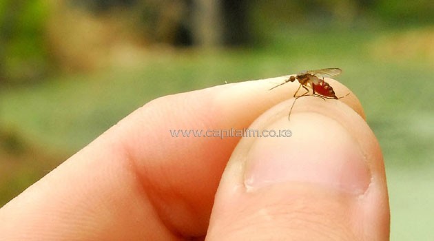
His team has worked on Rift Valley fever, a viral disease transmitted by mosquitoes that is found in Africa and on the Arabian Peninsula/XINHUA-File
“Some diseases are highly sensitive to their environment, especially parasitic diseases,” said Archie Clements, director of the school of population health at the Australian National University in Canberra.
“With remote sensing you can identify places where disease flourishes,” Clements told the annual meeting of the American Association for the Advancement of Science in San Jose, California.
“This information is useful for decision makers to help them ensure scarce resources are targeted to where they are most needed,” he said, noting that tropical diseases affect millions of people each year particularly in less developed nations.
Scientists use data transmitted by satellite on temperature, precipitation, soil moisture, vegetation type and land use, then analyze that information in a computer model.
“The result is maps that are accessible to countries with limited capacity for managing disease data, tailored to their local needs,” Clements said.
According to Kenneth Linthicum, director of the US Department of Agriculture Centre for medical agriculture and veterinary entomology in Florida, this approach helps government scientists “use environmental data, particularly global climate data, on a global scale to predict certain diseases before they occur.”
Satellite data can be particularly helpful in predicting the rise of mosquito-borne diseases, he told the conference.
His team has worked on Rift Valley fever, a viral disease transmitted by mosquitoes that is found in Africa and on the Arabian Peninsula.
The disease primarily affects livestock such as cattle, sheep and goats, killing the animals and wreaking economic havoc through food shortages and increasing prices on the people who rely on those animals for food and income.
Each time there were heavy rains that led to homes getting flooded, conditions were right for the disease-bearing mosquito eggs to hatch, scientists learned.
“We are able to predict those outbreaks two to five months before they occur and the real key there is by allowing us to predict disease that far in advance we can actually help warn people and implement control and mitigation strategies to reduce the impact of the diseases on animals and people,” he said.
The risk of coming epidemics are published on the USDA website as well as by the World Health Organization and the United Nations’s Food and Agriculture Organization (FAO).
For dengue in Africa, scientists have discovered that high heat and drought often precede an outbreak.
“The key is understanding the ecology and the transmission dynamics of the disease,” said Linthicum.
“You need to know what is going to happen before you go to the satellite data.”
The system doesn’t work quite as well with certain diseases, like malaria and chikungunya, with which a variety of environmental factors come into play.
While heat and dryness raise the risk of dengue in Africa, in Asia the same risk can be seen in times of heavy rain.
“But I think in a near future we will be able to predict many more of these diseases,” said Linthicum.
For Clements, the key challenge is getting important resources where they are needed before disaster strikes.
He described resource mobilization as a “critical problem.”